How GPS Changed Boating Forever
Before GPS, coastal navigation required charts, compasses, dividers, parallel rulers, and constant vigilance. Offshore passages meant celestial navigation with sextants and sight reduction tables. Today, a $150 chartplotter shows your exact position, heading, speed, and destination—all in real time.
The Global Positioning System uses 24+ satellites orbiting Earth to triangulate your position to within 10-30 feet (often better with WAAS correction). For recreational boaters, GPS has become the primary navigation tool, but understanding how it works—and its limitations—is critical for safe operation.
Understanding GPS Basics
GPS receivers calculate position by measuring the time delay of signals from multiple satellites. Each satellite broadcasts its exact position and the precise time. Your receiver compares arrival times from at least four satellites to determine your latitude, longitude, altitude, and time.
WAAS (Wide Area Augmentation System) improves accuracy to within 10 feet by using ground stations to correct satellite signal errors. WAAS is free and automatic on modern GPS units in North America.
Datum is the mathematical model of Earth’s shape used for mapping. Modern charts use WGS 84 (World Geodetic System 1984), which matches GPS. Older charts may use different datums—using the wrong datum can put you hundreds of yards off position. Always verify your GPS and chart use matching datums.
Types of Marine GPS Equipment
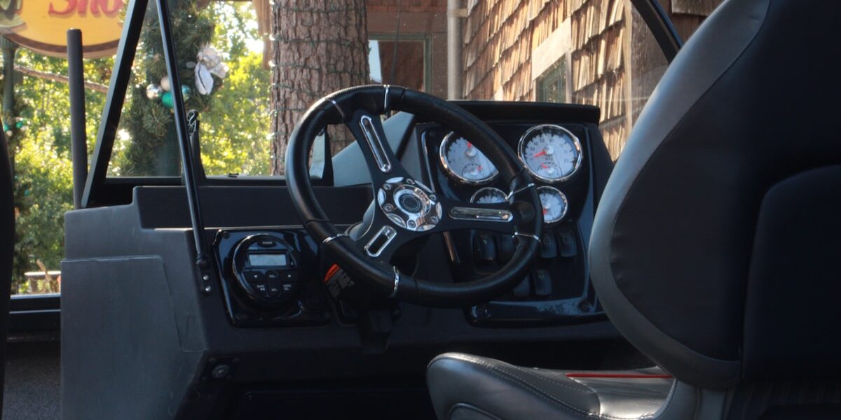
Chartplotters
Integrated units combining GPS receiver with electronic charts. Screen sizes range from 5″ portable units to 16″+ multifunction displays. Chartplotters show your position on detailed nautical charts, calculate routes, display depth, and integrate with radar, AIS, autopilot, and other systems.
Handheld GPS
Battery-powered portable units provide backup navigation. Marine-specific models float, are waterproof, and include basic chartplotting. Essential safety equipment—keep one charged with fresh batteries aboard.
Multifunction Displays (MFDs)
High-end systems combining GPS, charts, radar, sonar, AIS, weather, and engine monitoring on touchscreen displays. Networked MFDs share data, allowing redundant displays throughout the boat.
GPS/Smartphone Apps
Apps like Navionics, iNavX, and Garmin ActiveCaptain turn phones and tablets into functional chartplotters. Great for backup or small boats, but avoid relying on them as primary navigation—screens wash out in sunlight, batteries die quickly, and cellular GPS isn’t as accurate as dedicated marine receivers.
Electronic Charts: Raster vs Vector
Raster Charts (RNC) are digital scans of traditional paper charts. They look exactly like paper charts but allow zooming and GPS overlay. File sizes are large, and zooming in reveals pixelation.
Vector Charts (ENC) store chart data mathematically, allowing smooth zooming and customizable display. You can turn layers on/off (depths, lights, buoys, etc.) and adjust colors for day/night viewing. Most modern boaters prefer vector charts.
Popular chart brands include Navionics, C-MAP, Garmin BlueChart, and free NOAA charts. Update charts annually—navigation aids move, channels shift, and new hazards appear.
Essential GPS Functions
Waypoints
Saved locations marked by latitude/longitude. Create waypoints for marina entrances, fishing spots, anchorages, and navigation hazards. Name them clearly and back them up.
Routes
Chains of waypoints defining your planned track. Build routes on your chartplotter at home, checking for shallow water, rocks, and restricted areas. Don’t blindly follow straight-line routes—they may cross land or hazards.
Track Log
Your GPS records where you’ve been, creating a breadcrumb trail. Use track logs to retrace your path in fog or return to productive fishing areas. Save important tracks and clear old ones periodically.
Man Overboard (MOB)
Every GPS has a MOB button that instantly marks your current position and provides navigation back to that spot. Know where this button is and how to use it—seconds matter in MOB situations.
Course Over Ground (COG) vs Heading
Heading is the direction your bow points. COG is the direction you’re actually moving across the ground. Current and wind cause these to differ. GPS shows COG; your compass shows heading. In strong current, you may need to head 10-20° off your desired COG to make good your intended track.
Speed Over Ground (SOG) vs Speed Through Water
SOG is your actual speed across the earth’s surface (from GPS). Speed through water is your speed relative to the water (from a paddlewheel or pit log). In a 3-knot current, you might have 6 knots through water but 9 knots SOG (with current) or 3 knots SOG (against current).
GPS Navigation Techniques
Setting Up a Route
Zoom out to see the entire passage. Place waypoints at course changes, channel entrances, and before hazards. Zoom in and verify each waypoint is in safe water. Check the straight-line distance between waypoints doesn’t cross land or shallow areas.
Cross Track Error (XTE)
Shows how far left or right you’ve drifted from your intended route. Monitor XTE to stay on track in current or wind. Set XTE alarms to alert you if you drift more than a specified distance (typically 0.1-0.2 nautical miles).
Arrival Alarms
Set alarms to sound when you’re within a specified distance of your next waypoint (typically 0.1-0.25 NM). This prevents blowing past turns in busy waters or poor visibility.
GPS Limitations and Dangers
Chart Errors
Electronic charts are only as good as the surveys they’re based on. Remote areas may use data from 1800s surveys. Uncharted rocks, outdated depths, and shifted channels exist. GPS tells you where YOU are with high accuracy—it doesn’t guarantee the chart is accurate.
Zoom Danger
Zooming in creates a false sense of precision. At high zoom levels, a small rock might fill your screen, making it appear huge. Zoom out periodically to see the big picture. Don’t navigate zoomed in so far you can’t see hazards ahead.
Distraction
Staring at screens instead of watching the water causes collisions and groundings. GPS is a tool—use it, but keep your eyes outside scanning for traffic, debris, and changing conditions.
Over-Reliance
When GPS fails (and eventually it will—broken screen, dead batteries, water intrusion, software crash), do you know how to navigate with paper charts and compass? Maintain backup skills and equipment.
Integration with Other Systems
Modern boats network GPS with autopilots, radar, AIS, and other electronics using NMEA protocols. This integration enables powerful features:
- Autopilot: Steer to GPS waypoints automatically
- Radar overlay: Superimpose radar returns on your chart for precise collision avoidance
- AIS: Display nearby vessels’ positions, courses, and speeds on your chartplotter
- Depth sounder: Record depths along your track for future reference
- Weather: Overlay NOAA radar and forecasts on your position
Best Practices
Update charts and GPS firmware regularly. Carry backup power for your GPS (portable battery or hardwired to house bank, not just engine starting battery). Maintain paper charts for your cruising area and know how to use them. Practice navigation skills before you need them in emergencies.
Most importantly, use GPS as a tool to enhance situational awareness—not as a substitute for seamanship. The best navigators use GPS, radar, visual piloting, and traditional techniques together to build a complete picture of their position and surroundings.


Stay in the loop
Get the latest nautical soundings updates delivered to your inbox.